
Severe Storms Ahead Once Again For South, East
There’s an old saying about March "coming in like a lion, out like a lamb" that’s used to describe a trend that the month is supposed to begin stormy but end with calm weather.
For much of the eastern half of the country, that will not be the case this year.
A severe weather threat is expected in the final days of March, starting this weekend in the Midwest and South and then spreading to the East Coast by Monday.
This also marks the third weekend in a row with the potential for severe weather, a trend that started with the deadly tornado outbreak from March 14 through 16.
Timing
The new storm system could fire up a few severe storms as soon as Saturday night in the Midwest, but the more widespread potential is expected Sunday and Monday.
-Saturday Evening: Large hail and strong wind gusts are the primary concerns for any storms that turn severe Saturday evening into the overnight hours. The threat area extends from northeast Oklahoma through eastern Kansas and Missouri to western Illinois and parts of Iowa.

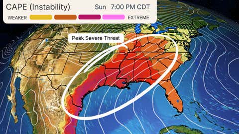
-Sunday-Sunday Night: An increasing threat of severe storms will develop Sunday afternoon and last into the overnight hours from eastern Texas to portions of the Mississippi, Ohio and Tennessee valleys. That includes St. Louis; Little Rock, Arkansas; Louisville, Kentucky; and Memphis and Nashville, Tennessee.
Damaging winds, very large hail and a few tornadoes are all potential threats, according to NOAA's Storm Prediction Center.
The potential for severe weather will likely erupt on the western side of the threat area shown below first, then spread eastward from there. That means severe weather will be a concern in the evening or overnight hours in some locations, especially in areas near and east of the Mississippi River, so be sure to have a way to receive alerts.
Uncertainty remains when it comes to the forecast threat level, so expect changes in the coming days.
(More: What the Storm Prediction Center's Thunderstorm Outlook Means)

-Monday: Severe weather will likely continue ahead of the cold front from the Southeast to the mid-Atlantic, possibly including Atlanta; Charlotte and Raleigh, North Carolina; Jacksonville, Florida; Columbia, South Carolina; and Richmond, Virginia.
Some severe weather could be ongoing in the morning hours, especially on the western edge of the threat area shown below. Through the day and into the early evening, those storms could intensify and new ones might form ahead of the cold front while spreading to the East Coast.
Wind damage, large hail and some tornado threat will accompany any storms that turn severe, but details are still uncertain.

Spring-Time Setup
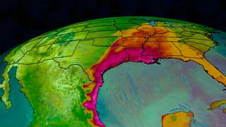
The setup supporting this multi-day severe weather threat is familiar for March and the rest of spring, with a sharp southward plunge of the jet stream swinging out of the West toward the central and eastern states.
A strong low pressure system with embedded strong wind shear will sweep from Kansas to New York over the weekend, helping pull a moisture surge northward from the Gulf. These will lead as potential drivers of severe weather, including supercells.
(192-hours: Further beef up your forecast with our detailed, hour-by-hour breakdown for the next 8 days – only available on our Premium Pro experience.)
Sara Tonks is a content meteorologist with weather.com and has a bachelor’s and a master’s degree from Georgia Tech in Earth and Atmospheric Sciences along with a master’s degree from Unity Environmental University in Marine Science.